Peru – M7.5 – November 28, 2021 at 10:52:13 UTC

M 7.5 - 42 km NNW of Barranca, Peru

Latitude Longitude Depth (km) Dist (Deg) Dist (Km) Azimuth
-4.49 -76.846 112.5 44.4 4,030.1 1.4


USGS Information Page

IRIS Information Page

Tectonic Summary

The November 28th, 2021, M 7.5 northern Peru earthquake occurred as the result of normal faulting at an intermediate depth, approximately 110 km beneath the Earth’s surface within the subducted lithosphere of the Nazca plate. Focal mechanism solutions indicate that rupture occurred on either a north-northwest or south-southeast striking, moderately dipping normal fault. At the location of the earthquake, the Nazca plate moves to the east relative to the South America plate at a velocity of about 70 mm/yr, subducting at the Peru-Chile Trench, to the west of the Peruvian coast and the November 28th earthquake. Earthquakes of northern Peru and most of western South America are due to strains generated by this ongoing subduction; at this latitude, the Nazca plate is seismically active to depths of about 650 km. This earthquake occurred in a segment of the subducted plate that has produced frequent earthquakes with focal depths of 100 to 150 km.

Earthquakes like this event, with focal depths between 70 and 300 km, are commonly termed “intermediate-depth” earthquakes. Intermediate-depth earthquakes represent deformation within subducted slabs rather than at the shallow plate interface between subducting and overriding tectonic plates. They typically cause less damage on the ground surface above their foci than is the case with similar-magnitude shallow-focus earthquakes, but large intermediate-depth earthquakes may be felt at great distance from their epicenters.

Large intermediate-depth earthquakes are reasonably common in this section of the Nazca slab, and five other intermediate-depth M 7+ events have occurred within 250 km of the November 28th earthquake over the past century. A M 7.5 earthquake on September 26th 2005, located at a similar depth but approximately 140 km to the south of the November 28th, 2021 earthquake, caused 5 deaths, about 70 injuries, and significant damage in the surrounding region. More recently, an M8.0 earthquake on May 26th 2019, approximately 230 km to the southeast of the November 28th 2021 earthquake, resulted in 2 deaths.

Local SeisComP3 P-wave Arrivals

Mexico – M7.0 – September 8, 2021 at 01:47:47 UTC

M 7.0 - Acapulco, Mexico

Latitude Longitude Depth (km) Dist (Deg) Dist (Km) Azimuth
16.982 -99.773 20.0


USGS Information Page

Tectonic Summary

The September 8, 2021 M7.0 (September 7 locally) earthquake near Acapulco in Guerrero, Mexico, occurred as a result of shallow thrust faulting on or near the plate boundary between the Cocos and North America plates. The depth and focal mechanism solutions of the event are consistent with the earthquake occurring on the subduction zone interface (approximately 20 km deep) between these plates. The earthquake occurred approximately 60 km northeast of the Middle America Trench where the Cocos plate begins its descent into the mantle beneath Mexico. In the region of this earthquake, the Cocos plate moves approximately northeastward at a rate of 65 mm/yr.

While commonly plotted as points on maps, earthquakes the size of the September 8, 2021 event are more appropriately described as slip over a larger fault area. Earthquakes of this size are typically about 40×20 km (length x width).

Historically, several significant earthquakes have occurred along the southern coast of Mexico. In the past 100 years, 17 earthquakes of M7 or larger have occurred within 250 km of the September 8, 2021 earthquake. An M7.0 earthquake occurred on May 11, 1962 in approximately the same location as the September 8, 2021 earthquake. The 1962 earthquake caused four fatalities, extensive regional infrastructure damage, and a local tsunami with a peak recorded amplitude of 2.8 meters. An M7.6 earthquake occurred about 75 km away on July 28, 1957. The September 2021 earthquake occurred at the southeastern end of the Guerrero Gap, a segment of the Middle America subduction zone that is thought to be capable of producing M8 or greater earthquakes. Seismic gaps are regions of faults or plate boundaries that exhibit relative seismic quiescence where previous large earthquakes are known or thought to have occurred. The Guerrero Gap extends ~230 km northwestward from Acapulco along the south Mexico coast. The last large (>M7) earthquake know to have occurred in the Guerrero Gap was in 1911; however, several notable yet smaller earthquakes (M6.1-6.7) have occurred within the region defined by the seismic gap.

Local SeisComP3 P-wave Arrivals

Haiti – M7.2 – August 14, 2021 at 12:29:08 UTC

M 7.2 - 13 km SSE of Petit Trou de Nippes, Haiti

Latitude Longitude Depth (km) Dist (Deg) Dist (Km) Azimuth
18:408 -73.475 10.0 21.7 2405 355.5


USGS Information Page

Tectonic Summary:

The August 14, 2021 M 7.2 Haiti earthquake occurred as the result of oblique reverse motion along the Enriquillo-Plantain Garden fault zone, ~125 km west of the Haitian capital Port-au-Prince. The earthquake occurred at shallow depths on either a reverse fault striking west and dipping to the north with a component of left-lateral slip, or a fault striking southeast and dipping to the southwest with a component of right-lateral slip. At the location of the earthquake, the local plate boundary is dominated by left-lateral strike slip motion and compression. The plate boundary in this location accommodates eastward, left-lateral motion of the Caribbean plate relative to the North America plate. Within this context, the earthquake likely occurred on the east-west striking, north dipping fault plane with a component of left-lateral slip.

On January 12, 2010, an M 7.0 earthquake struck the same peninsula of Haiti and was located ~75 km east of the August 2021 earthquake. The 2010 earthquake caused substantial damage in the city of Port-au-Prince and the surrounding regions where damage from the earthquake and subsequent cascading hazards caused over 200,000 fatalities. The August 2021 earthquake likely occurred within the same fault system as the January 2010 earthquake; however, the 2010 earthquake occurred on a blind thrust fault and not directly on the main plate-boundary fault.

The location and focal mechanism solutions of the August 2021 earthquake are consistent with the event resulting from primarily reverse faulting with a component of left-lateral strike slip faulting on the Enriquillo-Plantain Garden fault zone (EPGFZ). Overall, the EPGFZ accommodates about 7 mm/yr of motion, nearly half the total oblique convergence between the Caribbean and North America plates (~20 mm/yr). Haiti occupies the western part of the island of Hispaniola, one of the Greater Antilles Islands, situated between Puerto Rico and Cuba. At the location of the August 2021 earthquake, motion between the Caribbean and North America plates is partitioned between two major east-west-trending, strike slip fault systems—the Septentrional fault system in northern Haiti and the EPGFZ in southern Haiti.

The EPGFZ had produced a series of major earthquakes in both instrumental and historical time periods. In addition to the 2010 M 7 earthquake that devastated Port-au-Prince, the EPGFZ is the likely source of historical large earthquakes in 1860, 1770, and 1751, though none of these has been confirmed in the field as associated with this fault. The sequence of events possibly associated with the Enriquillo fault in 1751–1860 are as follows:

October 18, 1751: a major earthquake caused heavy destruction in the Gulf of Azua (the eastern end of the Enriquillo fault); this earthquake also generated a tsunami. It is unclear if the rupture occurred on the Muertos reverse belt or on the eastern end of the Enriquillo fault.

November 21, 1751: a major earthquake destroyed Port-au-Prince but was centered to the east of the city on the Plaine du Cul-de-Sac.

June 3, 1770: a major earthquake destroyed Port-au-Prince again and appeared to be centered west of the city. As a result of the 1751 and 1770 earthquakes and minor earthquakes that occurred between them, local authorities required building with wood and forbade building with masonry.

April 8, 1860: a major earthquake occurred farther west of the 2010 earthquake and was accompanied by a tsunami.

An M6.9 earthquake in Alaska (an aftershock to a previous M8.2 earthquake on July 29, 2021) preceded the Haiti earthquake by ~31 minutes. Despite the timing coincidence between these two earthquakes, the large distance between these two events makes a causal relationship unlikely.

Local SeisComP3 P-wave Arrivals

Alaska – M8.2 July 29, 2021 at 06:15:47

M 8.2 - 104 km SE of Perryville, Alaska

Latitude Longitude Depth (km) Dist (Deg) Dist (Km) Azimuth
55.325 -157.841 32.3 54.2 6,021 69.7


USGS Information Page

Tectonic Summary

The July 29, 2021, (July 28, 2021 local time) M8.2 earthquake southeast of Perryville, Alaska (south of the Alaska Peninsula), occurred as the result of thrust faulting on or near the subduction zone interface between the Pacific and North America plates. The preliminary focal mechanism solution indicates rupture occurred on a fault dipping either shallowly to the northwest, or steeply to the southeast. The location, mechanism and depth – and the large size of the event – are all consistent with slip occurring on the subduction zone interface between the two plates. At the location of this event, the Pacific plate converges with North America to the northwest at a rate of about 64 mm/yr, subducting at the Alaska-Aleutians trench ~125 km to the southeast of the earthquake.

While commonly plotted as points on maps, earthquakes of this size are more appropriately described as slip over a larger fault area. Reverse faulting events of the size of the July 29 earthquake are typically about 200×80 km in size (length x width).

Large earthquakes are common in the Alaska-Aleutian subduction zone. Since 1900, 8 other earthquakes M7 and larger have occurred within 250 km of the July 29, 2021 event, including earthquakes of M7.8 on July 22, 2020 (located 62 km west of the July 29, 2021 event) and M7.6 on October 19, 2020 (located 145 west of the July 29, 2021 event). Given the temporal and spatial proximity of the July 29, 2021 earthquake to the two previous large earthquakes in July and October 2020, those previous events were foreshocks of the July 2021 earthquake. An earthquake of M8.2 also occurred on November 10, 1938 within 40 km of the July 29, 2021 event. While initial information is incomplete, the July 29 earthquake may have ruptured partially or completely into the ruptured region of the 1938 earthquake.

The Alaska-Aleutian Trench also hosted the second largest earthquake recorded by modern seismic instrumentation, the M9.2 March 27 1964 earthquake, which ruptured to within about 250 km of this event, at the eastern end of the 1938 rupture area. The 1938 event produced a small tsunami that was recorded both locally and in Hilo, Hawaii. The remote location of the earthquake resulted in little impact to people and infrastructure.

Local SeisComP3 P-wave Arrivals

New Zealand – Kermadec Islands Earthquake Sequence – March 4, 2021

M 7.3 - 174 km NE of Gisborne, New Zealand, M 7.4 - Kermadec Islands, New Zealand, M 8.1 - Kermadec Islands, New Zealand

Time Latitude Longitude Depth (km) Magnitude Dist (Deg) Dist (Km) Azimuth
13:27:36 -37.563 179.444 20.8 7.3 123.4 13,697 62.4
17.41.24 -29.665 -177.834 53.1 7.4 117.5 13,039 57.5
19:28:32 -29.735 -177.282 26.5 8.1 117.1 12,999 57.4


USGS Information Page – M 7.3 – 174 km NE of Gisborne, New Zealand

USGS Information Page – M 7.4 – Kermadec Islands, New Zealand

USGS Information Page – M 8.1 – Kermadec Islands, New Zealand


Tectonic Summaries

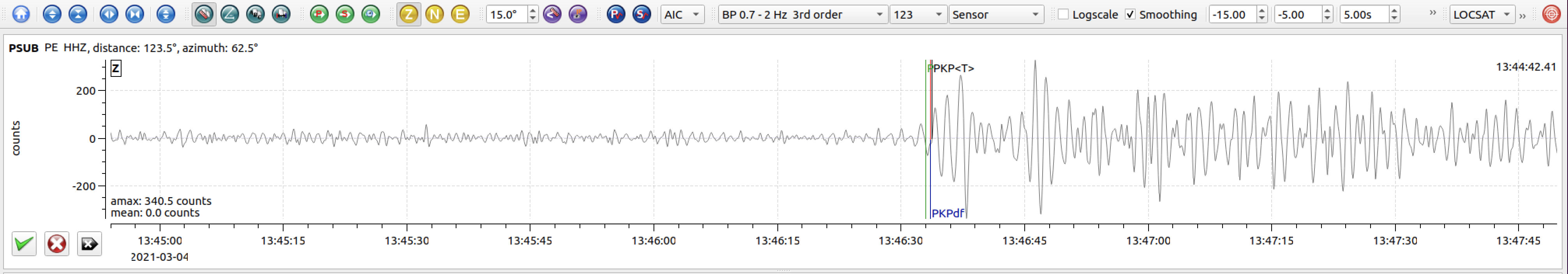
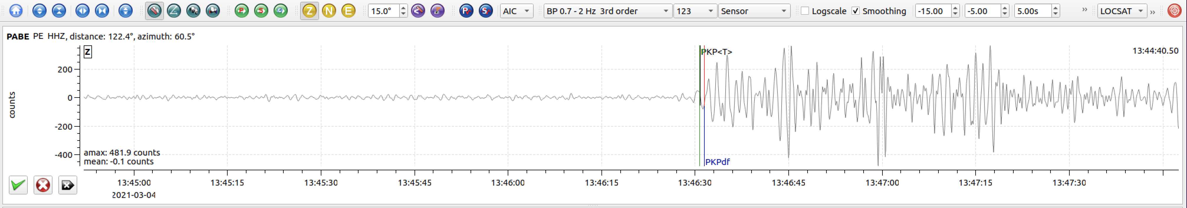
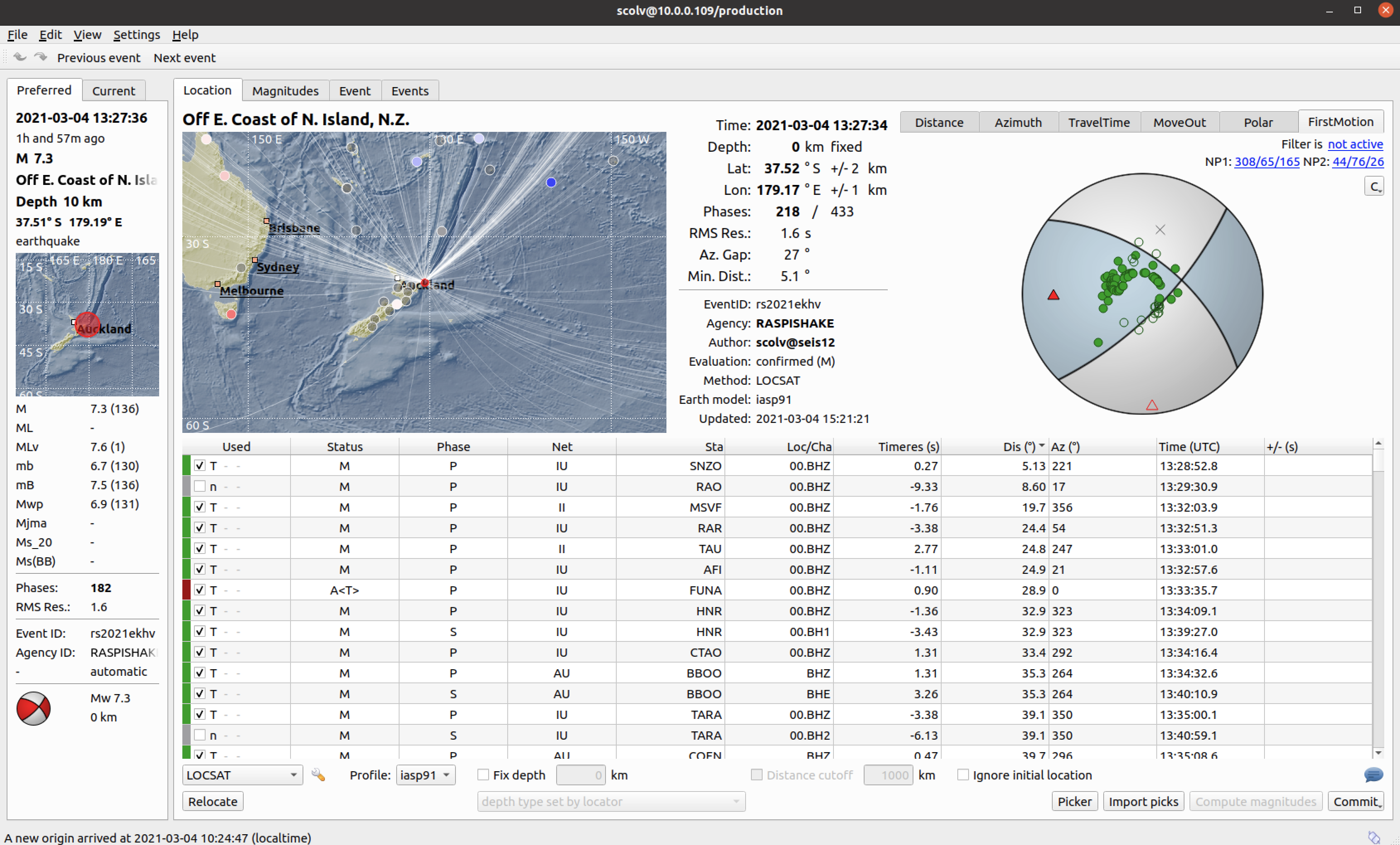
The March 4, 2021 M 7.3 earthquake northeast of Gisborne, New Zealand occurred as the result of oblique reverse faulting at approximately 20 km depth near the plate boundary between the Pacific and Australia plates. Preliminary moment tensor solutions indicate that the earthquake likely occurred on either a north-east dipping reverse fault with oblique right-lateral strike slip motion, or on a south-east dipping reverse fault with oblique left-lateral strike slip motion. The Pacific plate begins its westward subduction beneath the Australia plate at the Kermadec and Hikurangi subduction zone trenches with a velocity of about 47 mm/yr. The location, depth, and faulting mechanisms associated with this earthquake indicate that the earthquake likely occurred within the subducted Pacific lithosphere very close to the oceanic trench between these two tectonic plates.

While commonly plotted as points on maps, earthquakes of this size are more appropriately described as slip over a larger fault area. Oblique faulting events of the size of the March 4 earthquake are typically about 85x25km in size (length x width).

The Australia-Pacific plate boundary region east of the North Island of New Zealand has a history of large earthquakes both along the plate boundary proper, within the subducting Pacific Plate, and in the overlying Australia plate. Seismic activity is especially high in the Kermadec Islands region to the north. Within 250 km of the March 4, 2021 event, four earthquakes of M 7 or greater have occurred in the past century, with the most recent being an M7.0 oblique normal faulting earthquake in September 2016. The March 4, 2021 earthquake occurred ~45 km east-southeast of the September 2016 normal faulting earthquake. There have been 29 earthquakes of M 6 or greater within 250 km of the March 4 earthquake over the same time period. Despite the subduction zone environment, previous earthquake mechanisms in the vicinity of the March 4 earthquake exhibit a diverse range of faulting styles including predominantly thrust motion, normal motion, and oblique strike slip motion.


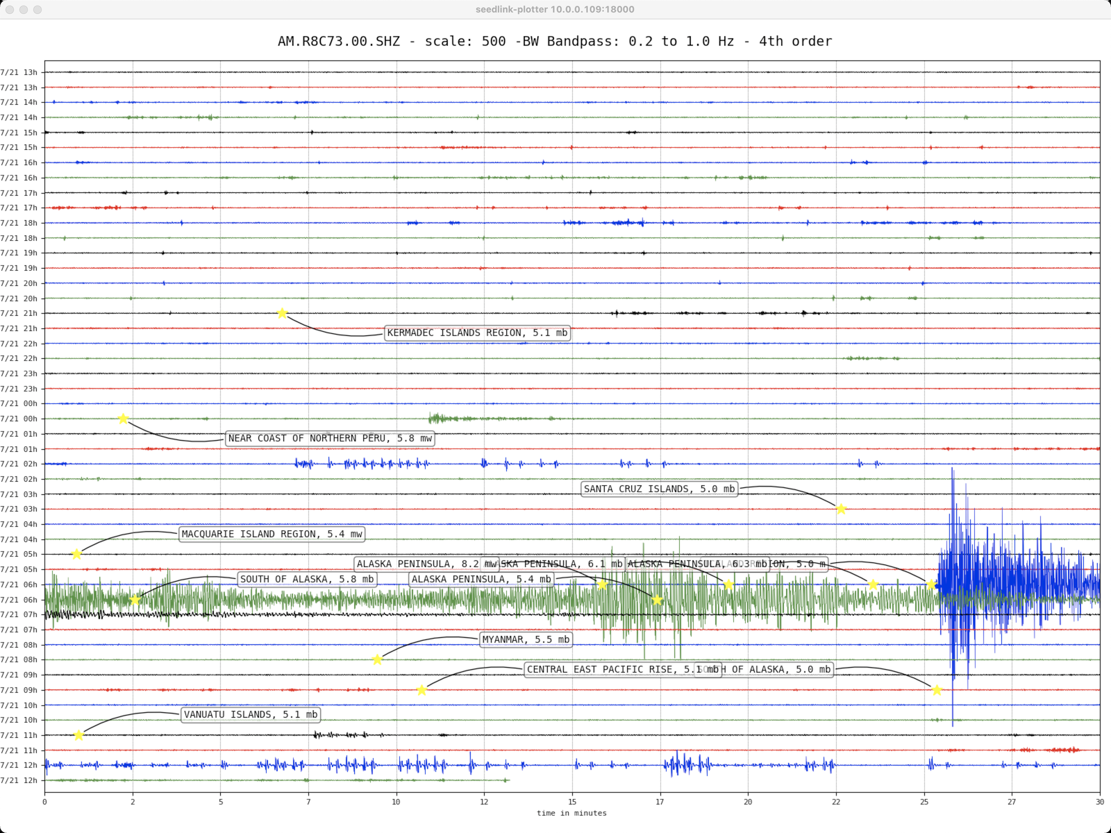
The March 4, 2021 M 8.1 earthquake near Kermadec Islands, New Zealand occurred as the result of reverse faulting in the Tonga-Kermadec subduction zone at a depth of ~22 km. The Tonga-Kermadec subduction zone extends north-northeast from the North Island of New Zealand for more than 2,500 km through Tonga to within 100 km of Samoa. Focal mechanism solutions for the event indicate rupture occurred as a result of reverse faulting, either by low angle thrust motion on a west-dipping fault or by high angle reverse motion on an east-dipping fault. The location, depth, and style of faulting are consistent with the earthquake having occurred on or near the west-dipping subducting plate interface between the Pacific and Australia plates.


The March 4 2021 M 8.1 earthquake was preceded ~107 minutes by an M 7.4 thrust earthquake located ~50 km west of the M 8.1. The proximity and timing of the two events indicates that the M 7.4 was likely a foreshock of the M 8.1 earthquake. In terms of seismic moment, the M 8.1 was ~11 x larger than the M 7.4 foreshock. Additionally, a M 7.3 oblique reverse faulting earthquake occurred ~6 hours prior to the M 8.1 and ~900 km to the south; however, the spatial and temporal gap between these earthquakes likely indicates that static stress changes induced by the earlier M 7.3 did not directly cause the M 7.4 or M 8.1 earthquakes.

At the location of the earthquake, the Pacific plate moves westward relative to the Australia plate at a velocity of about 60 mm/yr, subducting to the west beneath the Australia plate at the Tonga and Kermadec Trenches. The eastern edge of the Australia plate may itself be viewed as a collection of microplates whose relative motions help to accommodate the overall Pacific-Australia convergence and associated back-arc spreading. The location and focal mechanism solutions of the earthquake are consistent with it occurring on or near the westward-dipping interface between the subducting Pacific plate and the overriding Australia plate.

While commonly plotted as points on maps, earthquakes of this size are more appropriately described as slip over a larger fault area. Reverse events of the size of the March 4 earthquake are typically about 175 km long x 75 km wide (fault length x fault width).

The interaction between the Pacific and Australia plates creates one of the most seismically active tectonic environments in the world. In the past century, 215 earthquakes >M 6 have occurred within 250 km of the M 8.1 earthquake, including the M 7.4 that occurred ~107 minutes prior. The largest previous event was a M 8 earthquake in January 1976, more than 100 km to the north, with no associated casualties or damage.


Local SeisComP3 P-wave Arrivals

Chile – M6.7 – December 27, 2020 at 21:39:14 UTC

146 km WNW of Corral, Chile

Latitude Longitude Depth (km) Dist (Deg) Dist (Km) Azimuth
-39.343 -74.990 10.0 79.2 8,789 359.2


USGS Information Page

Local SeisComP3 P-wave Arrivals