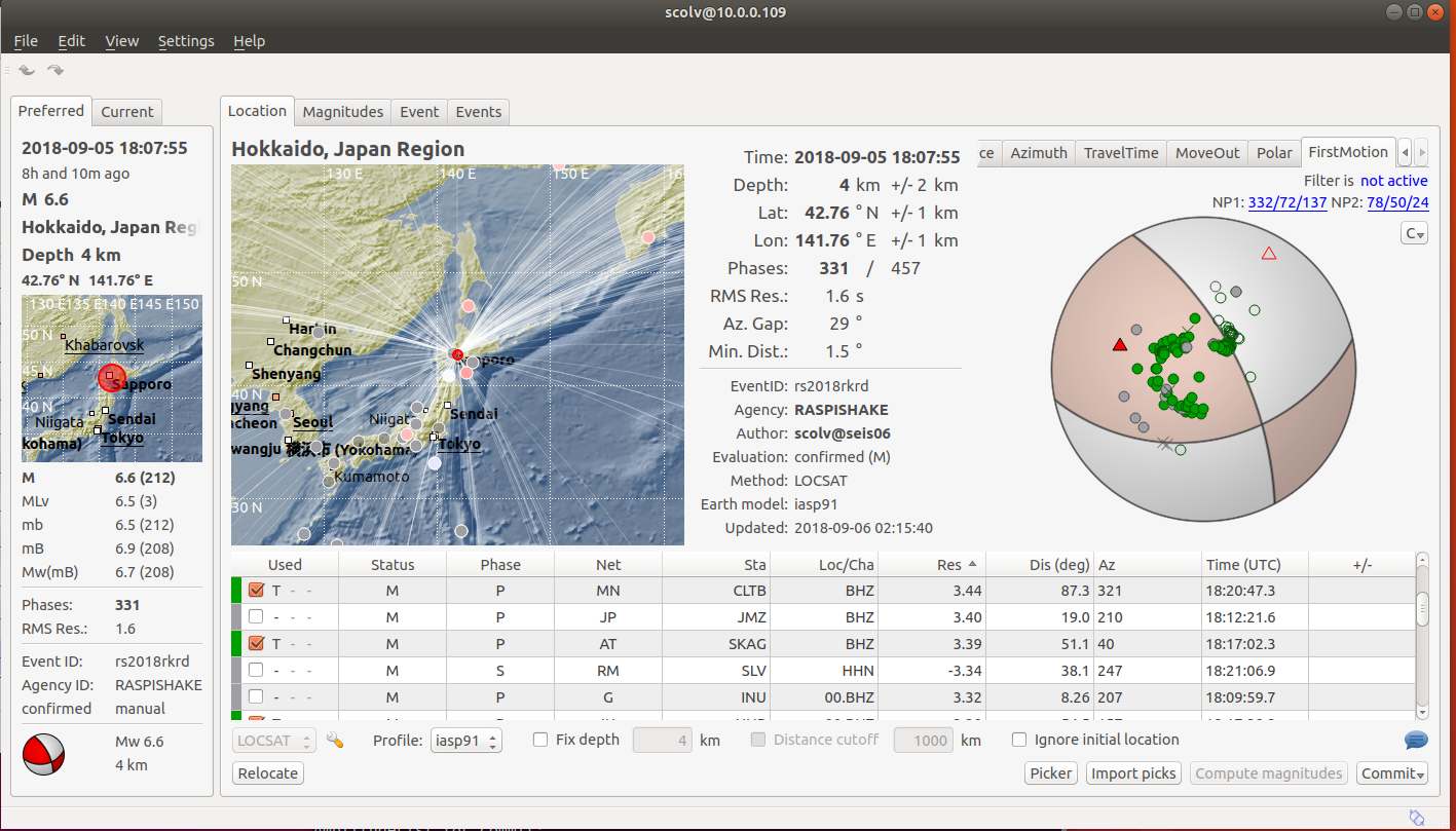
The September 6, 2018, M 7.8 earthquake just offshore of the islands of Fiji occurred as the result of deep, oblique strike-slip faulting approximately 610 km beneath the South Pacific Ocean about 900 km to the west of the Tonga Trench. Focal mechanism solutions indicate that rupture occurred on a steeply dipping normal fault striking to the northwest or to the southeast. At the location of this earthquake, the Pacific plate moves approximately due west relative to the Australia plate at a velocity of about 81 mm/yr. This earthquake lies near the base of the inclined seismic zone that defines the subducting Pacific Plate, which subducts westward beneath the Australia plate at the Tonga Trench. The earthquake occurred in response to stresses generated by the slow distortion of the Pacific plate at depth, rather than on the shallow thrust fault that constitutes the interface between the two and which is seismically active near the Earth’s surface. Slip on a fault aligned with either nodal plane of the focal mechanism solution is consistent with this intraplate setting.
This figure shows a cross-section though the subducting Pacific slab near Fiji, in the northern Tonga-Kermadec subduction zone. The inset indicates the location of the cross-section (white line), overlain on the USGS Slab2 model of the geometry of the Pacific plate at depth. The diamond shows the location of the 08-19-18 M 8.2 event, while the star indicates the location of the 09-06-18 M 7.8 earthquake. The main panel shows historic seismicity (circles, colored by depth) from a side-on view. Beachballs indicate focal mechanism solutions for many of these historic earthquakes. The dashed line shows the location of the Pacific slab interface in the Slab2 geometry model. Again, the 08-19-18 and 09-06-18 events are shown by a diamond and star, respectively.
The Pacific slab at this location shows evidence of significant distortion at depth, with deep earthquakes associated with this subduction zone spanning several hundreds of kilometers laterally. Some authors have proposed this is evidence for a large slab fragment in this region, with a sub-horizontal geometry lying to the west of the main, steep Wadati-Benioff zone of the currently subducting Pacific slab. In this context, the September 6, 2018 earthquake (and perhaps the August 19, 2018 M 8.2 event before it) lies within the sub-horizontal relic slab.
Earthquakes that have focal depths greater than 300 km are commonly termed “deep-focus” earthquakes. Deep-focus earthquakes cause less damage on the ground surface above their foci than similar-magnitude shallow-focus earthquakes, but large deep-focus earthquakes may be felt at great distance from their epicenters. This earthquake is similar in size to the largest observed deep-focus earthquakes. The largest recorded deep-focus earthquake to date was the M 8.3 event that occurred at a depth of 600 km within the subducted Pacific plate beneath the Sea of Okhotsk offshore of northeastern Russia in 2013. The M 8.3 Okhotsk earthquake was felt all over Asia, as far away as Moscow, and across the Pacific Ocean along the western seaboard of the United States (though at distant locations, individuals reporting having felt the event were likely very favorably situated for the perception of small ground motions). The M 8.2 Bolivian deep-focus earthquake in 1994 had similarly been reported by individuals in North America at great distance from the epicenter.
Over the past century, 96 earthquakes with a magnitude of M 7+ have occurred at depths greater than 300 km globally; 6 of these were located in the same region as the September 6, 2018, event. The largest nearby event at these depths was a M 8.2 earthquake on August 19, 2018, about 270 km to the east of and at a similar depth to the September 6, 2018 event. While today’s M 7.8 earthquake demonstrates a strike-slip mechanism, the August M 8.2 event occurred as the result of northwest or southeast striking normal faulting. To date, the August event has been followed by close to 150 M 4+ aftershocks in the immediate vicinity of that event, the largest of which was a M 6.3 earthquake minutes after the M 8.2 mainshock. Further investigations will be required to reveal what, if any, connection exists between the August 19, M 8.2 earthquake, and today’s M 7.8 event nearly three weeks later.
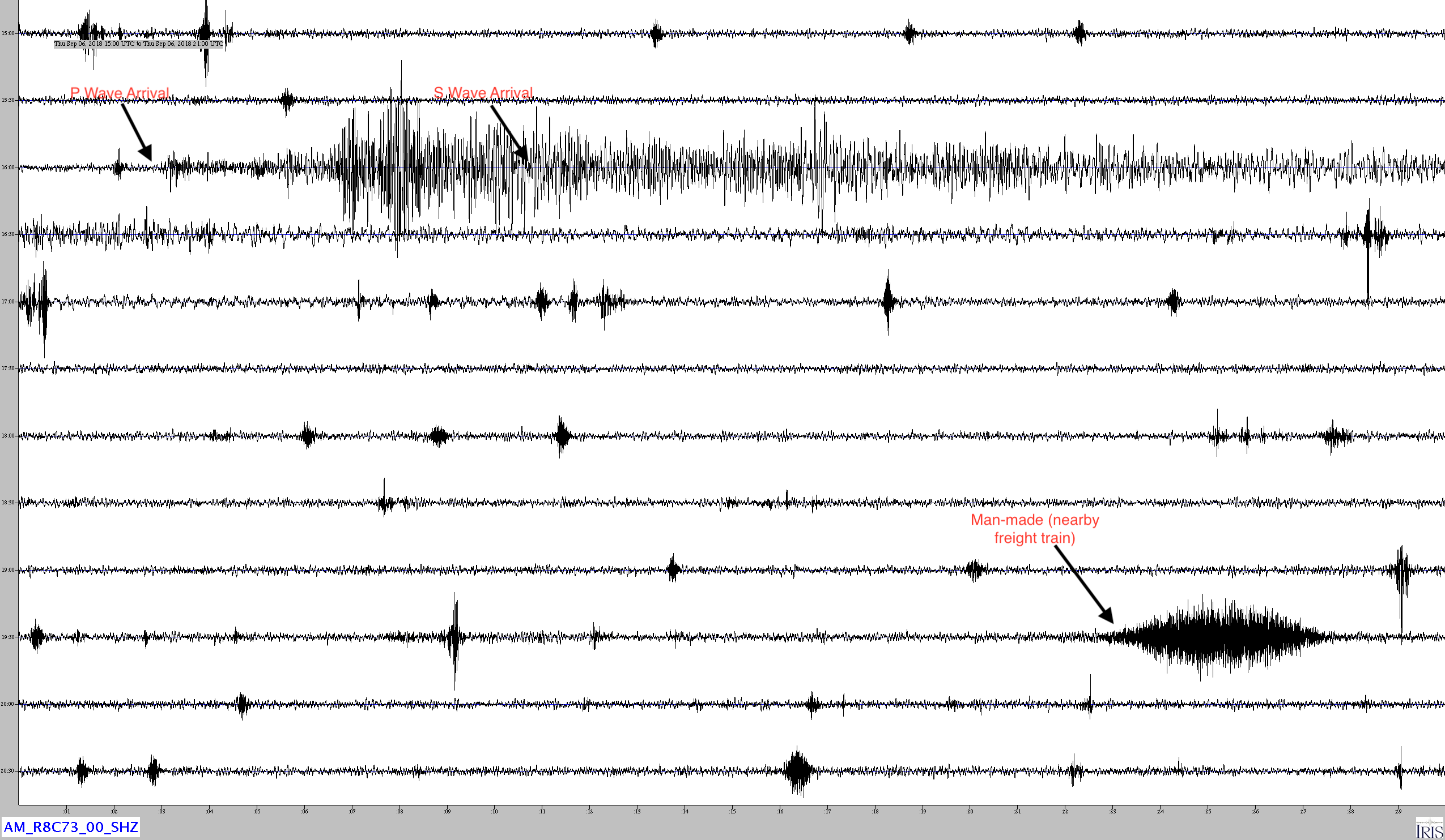
Jamaseis heliocoder trace of AM.RC8C73.00.SHZ. The P and S wave arrivals are annotated Distance: 113.2 Deg. 12,577 km Azimuth: 53.5 Deg.
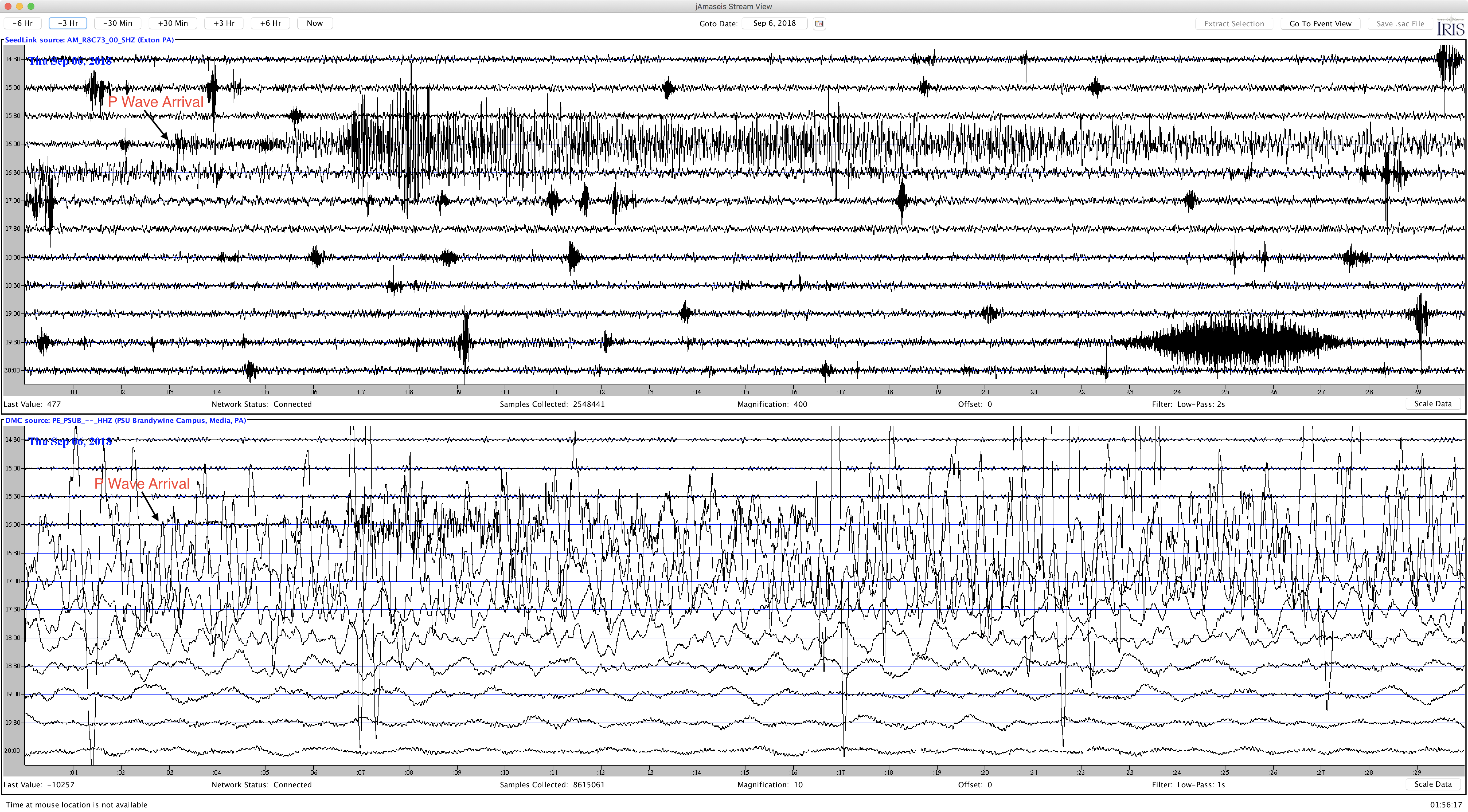
This Jamaseis image compares the short period RaspberryShake (AM.R8C73.00.SHZ) trace with that of a broadband seismometer (PE.PSUB.HHZ) in nearby Media PA. Note that PSUB shows the large low frequency surface waves which cannot be detected by the RaspberryShake.
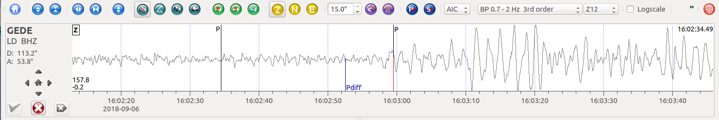
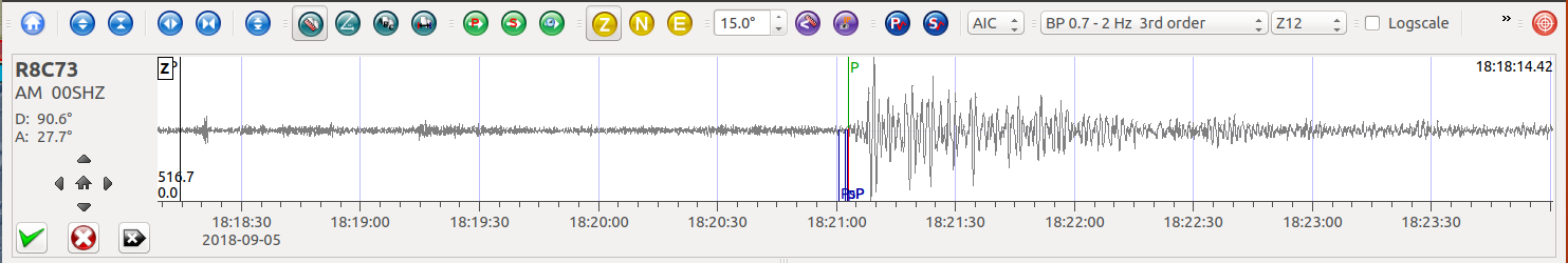
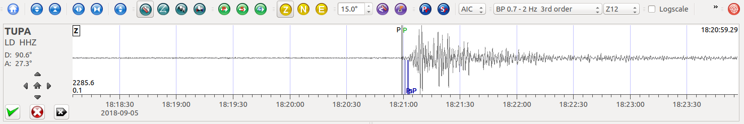
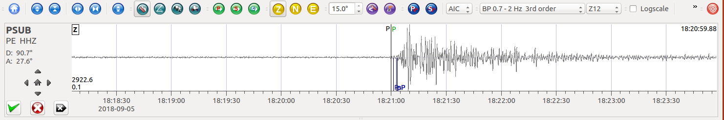
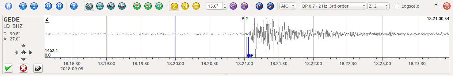
SeisComP3 images of AM.R8C73.00.SHZ *Exton P), LD.TUPA.HHZ (Ambler PA), and LD.GEDE.BHZ (Greenville DE).
Significant damage and casualties occurred in southwestern Hokkaido due to this quake.
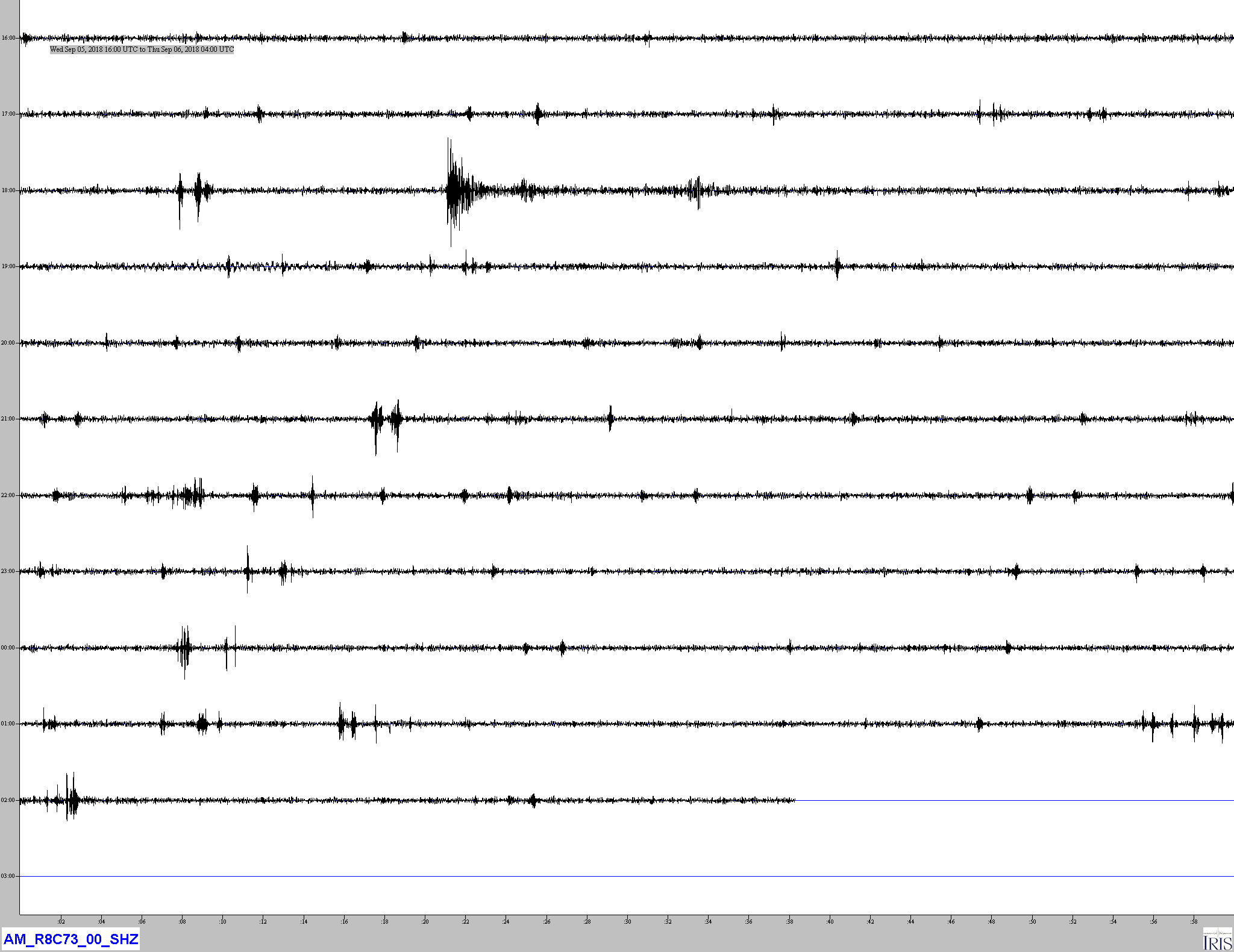
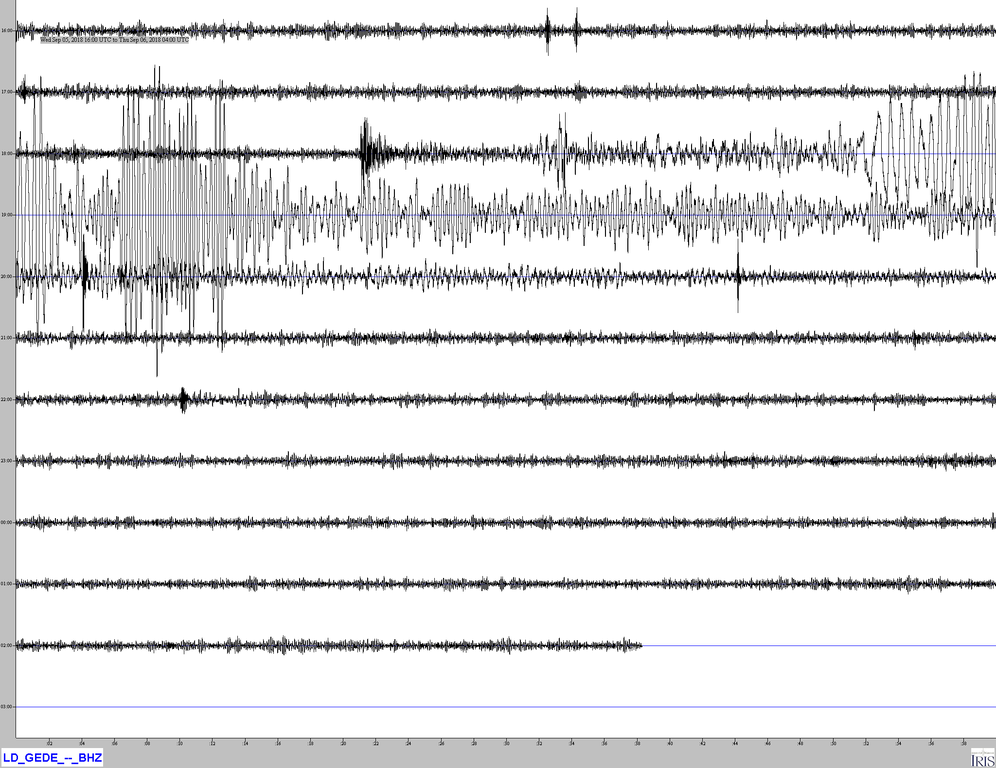
Jamaseis heliocoder trace of AM.RC8C73.00.SHZ (Exton PA) and LD.GEDE.BHZ (Greenville DE). Note that while the body waves (upper left) traces are similar, LD.GEDE.BHZ shows extended high amplitude surface waves, typical for a broadband seismometer.
Distance: 90.6 deg, 10,100 km
Azimuth: 27.7 deg
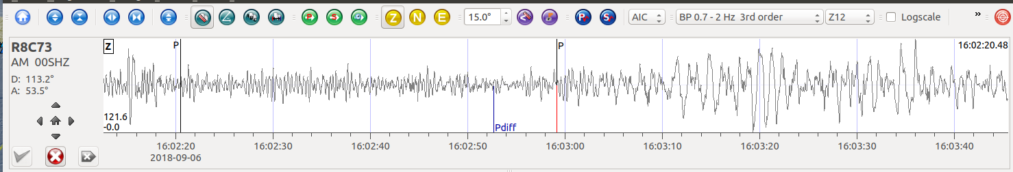
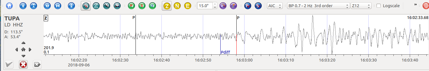
SeisComP3 traces for AM.R8C73.00.SHZ (Exton PA) and LD.TUPA.HHZ (Temple University Ambler Campus), PE.PSUB.HHZ (Penn State Delaware County Campus), and LD.GEDE.BHZ (Greenville DE) showing the P wave arrivals.
SeisComP3 display showing the Focal Mechanism for this event.
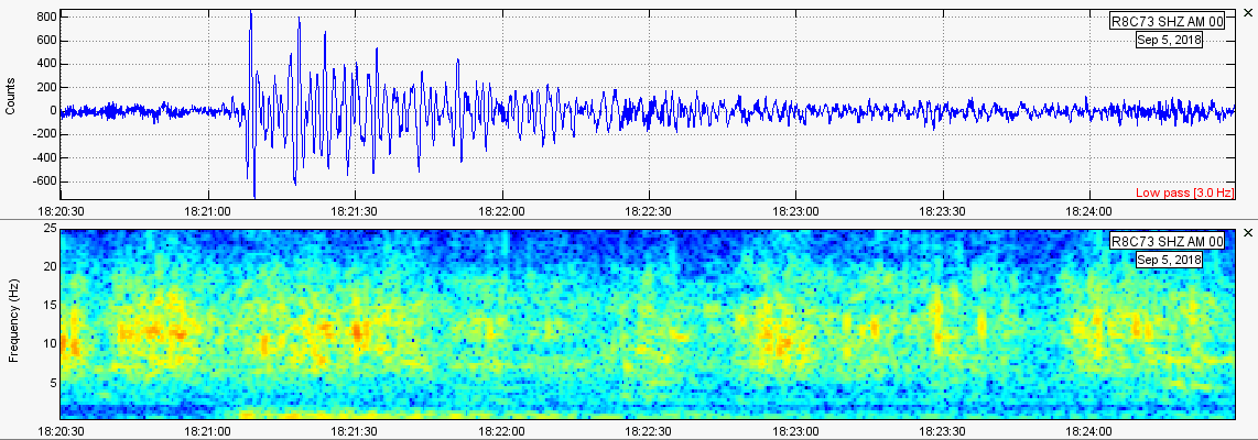
Another image of AM.R8C73.00.SHZ comparing the trace (with a lowpass filter at 3Hz applied) with the spectrum display (no filtering).
The August 29, 2018, M 7.1 earthquake about 300 km to the east of the island of New Caledonia in the southwest Pacific Ocean occurred as the result of thrust faulting on or near the plate boundary interface between the Australia and Pacific plates. Focal mechanism solutions indicate the earthquake occurred on either a shallow fault striking northwest, or on a steep fault striking southeast. At the location of this earthquake, the Australia plate moves towards the east-northeast with respect to the Pacific at a rate of approximately 78 mm/yr. At the South New Hebrides Trench, Australia lithosphere converges with and sinks beneath the Pacific plate, descending into the mantle and forming the New Hebrides/Vanuatu subduction zone, stretching from New Caledonia in the south to the Santa Cruz Islands in the north, a distance of about 1,600 km. The August 29, 2018 earthquake occurred approximately 50 km to the east of this trench, and its location, depth and focal mechanism solution are all consistent with it occurring on the subduction zone interface between the two plates.
The Loyalty Islands region is very active seismically, and the region within 250 km of the August 29, 2018 earthquake has hosted 20 other M 7+ earthquakes over the preceding century. The largest was a M 7.7 earthquake in May 1995, which was located about 100 km to the south of today’s event, and to the southwest of the oceanic trench in the region commonly referred to as the outer rise. One of the most proximate of these historic earthquakes was a M 7.3 thrust faulting event in December 2003, about 30 km to the west of today’s earthquake. The 2003 earthquake was part of an active sequence of about 250 M 4+ events, beginning in December 2003 and continuing into February 2004. That sequence included both interplate thrust faulting earthquakes (the largest event in the sequence was the M 7.3 earthquake) and normal faulting earthquakes to the west of the oceanic trench (the largest being a M 7.1 earthquake in January 2004). A similar sequence of interplate thrust and outer rise normal faulting earthquakes occurred in October-December 2017, just to the north of the 2003-04 sequence. The 2017 sequence began with a M 6.7 thrust faulting earthquake on October 31, 2017. The largest event in the sequence was a M 7.1 outer rise earthquake on November 19, 2017. Between the M 6.7 earthquake and December 25, 2017, about 350 M 4+ events occurred as part of that sequence. Because of their remote locations far from land, these earthquakes do not cause significant shaking in populated areas and are not known to have resulted in damage or fatalities.
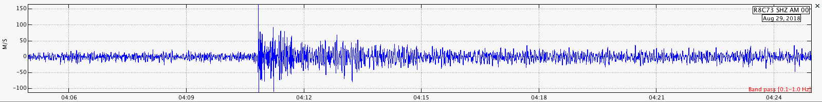
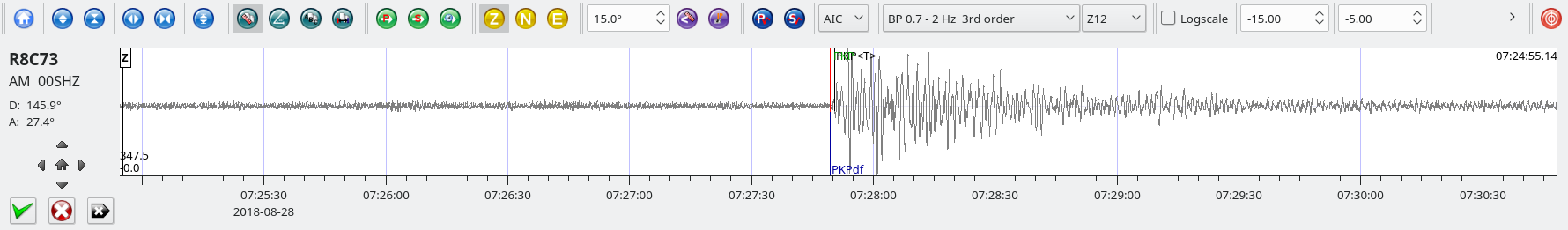
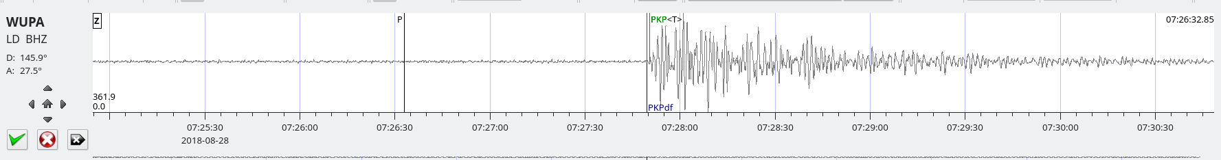
Trace of AM.RC8C73.00.SHZ. The initial P wave arrival (at about 04:07 ) is not noticeable. This would be a P wave diffracted at the mantle-core boundary. The higher amplitude waves about minutes later are P waves traveling through into the core and diffracted at the outer-inner core boundary (PKPdf). Beyond 120 degrees the PKPdf is the primary P observed.
Distance: 122.6 deg, 13,596 km
Azimuth: 55.6 Deg.
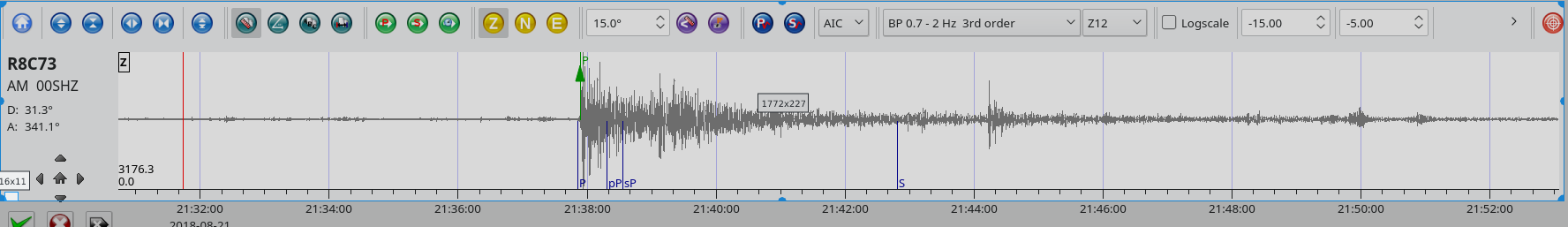
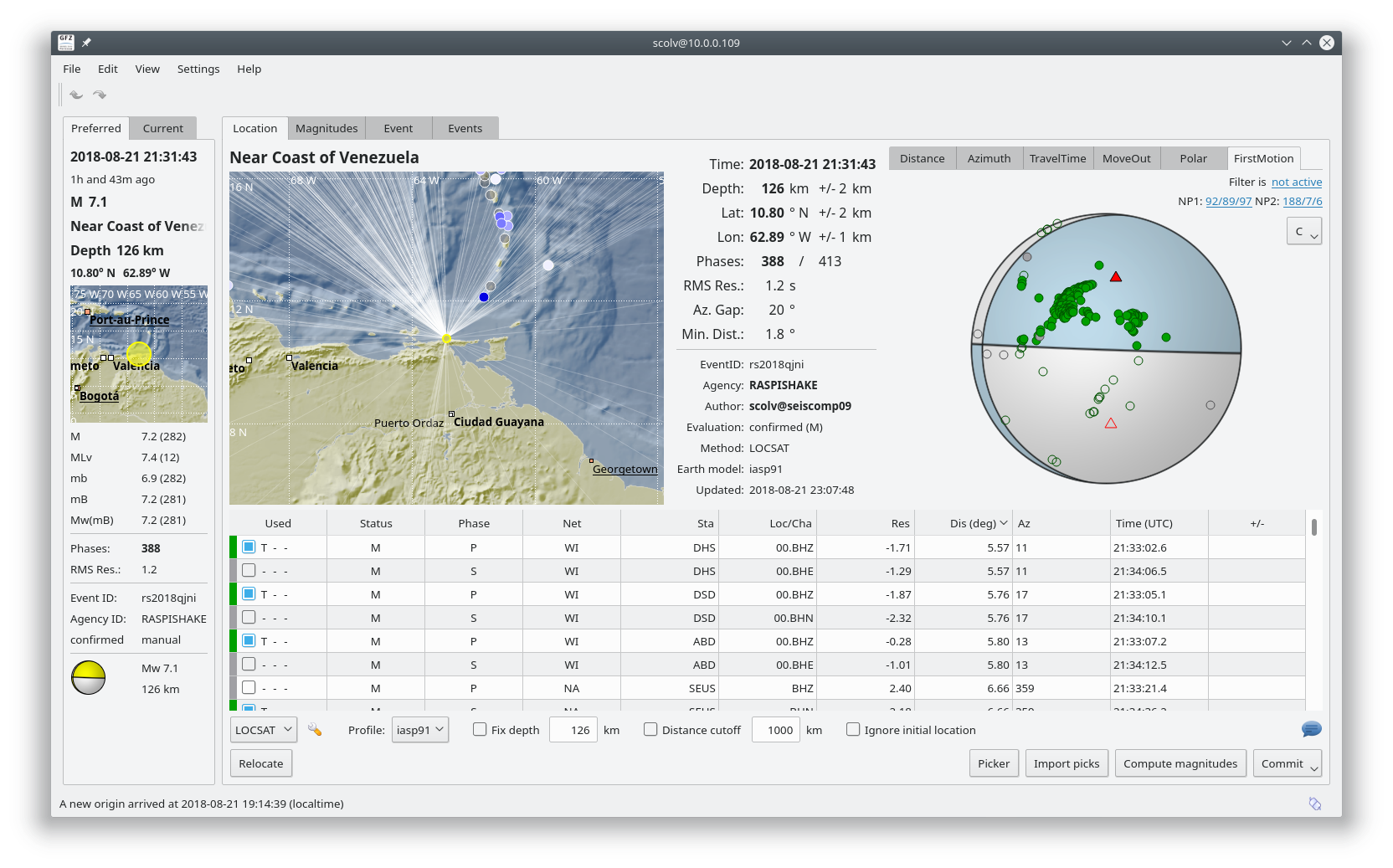
“The August 21, 2018, M 7.3 earthquake near the northern coast of Venezuela occurred as the result of oblique reverse faulting at intermediate depth. The focal mechanism solution indicates slip occurred on either a steep fault striking east-west, or on a shallow structure striking southeast. At the location of the earthquake, the South America plate moves westward with respect to the Caribbean plate at a rate of approximately 20 mm/yr. The South America plate begins its subduction beneath the Caribbean plate about 550 km to the east of today’s earthquake and reaches depths close to 150 km in the vicinity of this event. This earthquake occurred near the southern end of the Caribbean subduction zone. At shallow depth, the plate boundary in this region transitions to transform faulting along the San Sebastian – El Pilar fault system. The depth and focal mechanism solution of today’s earthquake is consistent with faulting at depth, within subducted lithosphere of the South America plate, rather than along the shallow right-lateral transform plate boundary.
While commonly plotted as points on maps, earthquakes of this size are more appropriately described as slip over a larger fault area. Oblique-thrust-faulting events of the size of the August 21st, 2018 earthquake are typically about 65×25 km (length x width).
Earthquakes like this event, with focal depths between 70 and 300 km, are commonly termed “intermediate-depth” earthquakes. Intermediate-depth earthquakes represent deformation within subducted lithosphere rather than at the shallow plate interfaces between subducting and overriding tectonic plates. They typically cause less damage on the ground surface above their foci than is the case with similar-magnitude shallow-focus earthquakes, but large intermediate-depth earthquakes may be felt at great distance from their epicenters. Earthquakes have been reliably located to depths close to 180 km in this region.
While there have been 17 previous M 6+ earthquakes in this region, large earthquakes are rare; this is the largest historic event within 250 km of this location in the 20th and 21st centuries. All prior damaging earthquakes in this region have been shallow.”
This earthquake was the first magnitude 8+ earthquake in 2018. Despite the intensity little damage occurred due the the extreme depth of the hypocenter.
“The August 18, 2018, M 8.2 earthquake near Fiji occurred as the result of deep, normal faulting approximately 560 km beneath the South Pacific Ocean several hundred kilometers to the west of the Tonga Trench. Focal mechanism solutions indicate that rupture occurred on a moderately dipping normal fault striking to the west-northwest or the east-southeast. At the location of this earthquake, the Pacific plate moves approximately due west relative to the Australia plate at a velocity of about 81 mm/yr. The location, depth, and focal mechanism solutions of the August 18th event indicate that the earthquake is related to faulting within the subducted Pacific slab.
Earthquakes that have focal depths greater than 300 km are commonly termed “deep-focus” earthquakes. Deep-focus earthquakes cause less damage on the ground surface above their foci than similar-magnitude shallow-focus earthquakes, but large deep-focus earthquakes may be felt at great distance from their epicenters. This earthquake is similar in size to the largest observed deep-focus earthquakes. The largest recorded deep-focus earthquake to date was the M 8.3 event that occurred at a depth of 600 km within the subducted Pacific plate beneath the Sea of Okhotsk offshore of northeastern Russia in 2013. The M 8.3 Okhotsk earthquake was felt all over Asia, as far away as Moscow, and across the Pacific Ocean along the western seaboard of the United States (though at distant locations, individuals reporting having felt the event were likely very favorably situated for the perception of small ground motions). The M 8.2 Bolivian deep-focus earthquake in 1994 had similarly been reported by individuals in North America at great distance from the epicenter.
Deep focus earthquakes are common near this event. Over the past century, 9 earthquakes with a magnitude of M 7+ have occurred within 250 km of this event, all at depths greater than 300 km. The largest of these prior to this event was an M 7.8 earthquake in January 1919.”
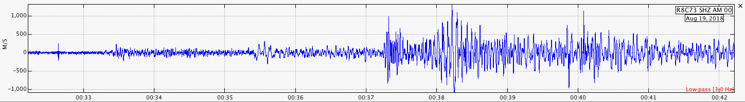
Trace of AM.RC8C73.00.SHZ (RaspberryShake 1D in Exton PA). Distance: 12,653km Azimuth: 53.4 Deg.
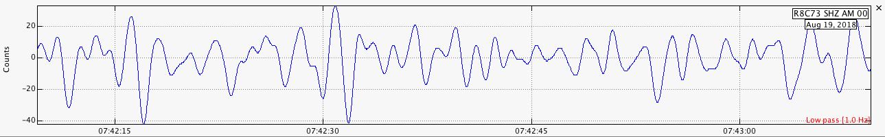
Large earthquakes such as this one produce surface waves that may travel around the world for hours or even days after the event. This image show surface waves recorded by AM.R8C73.00.SHZ 7 1/2 hours after the earthquake. As the RaspberryShake is a short period instrument, only the higher frequency waves (with a period of about 1 1/2 seconds) were recorded.