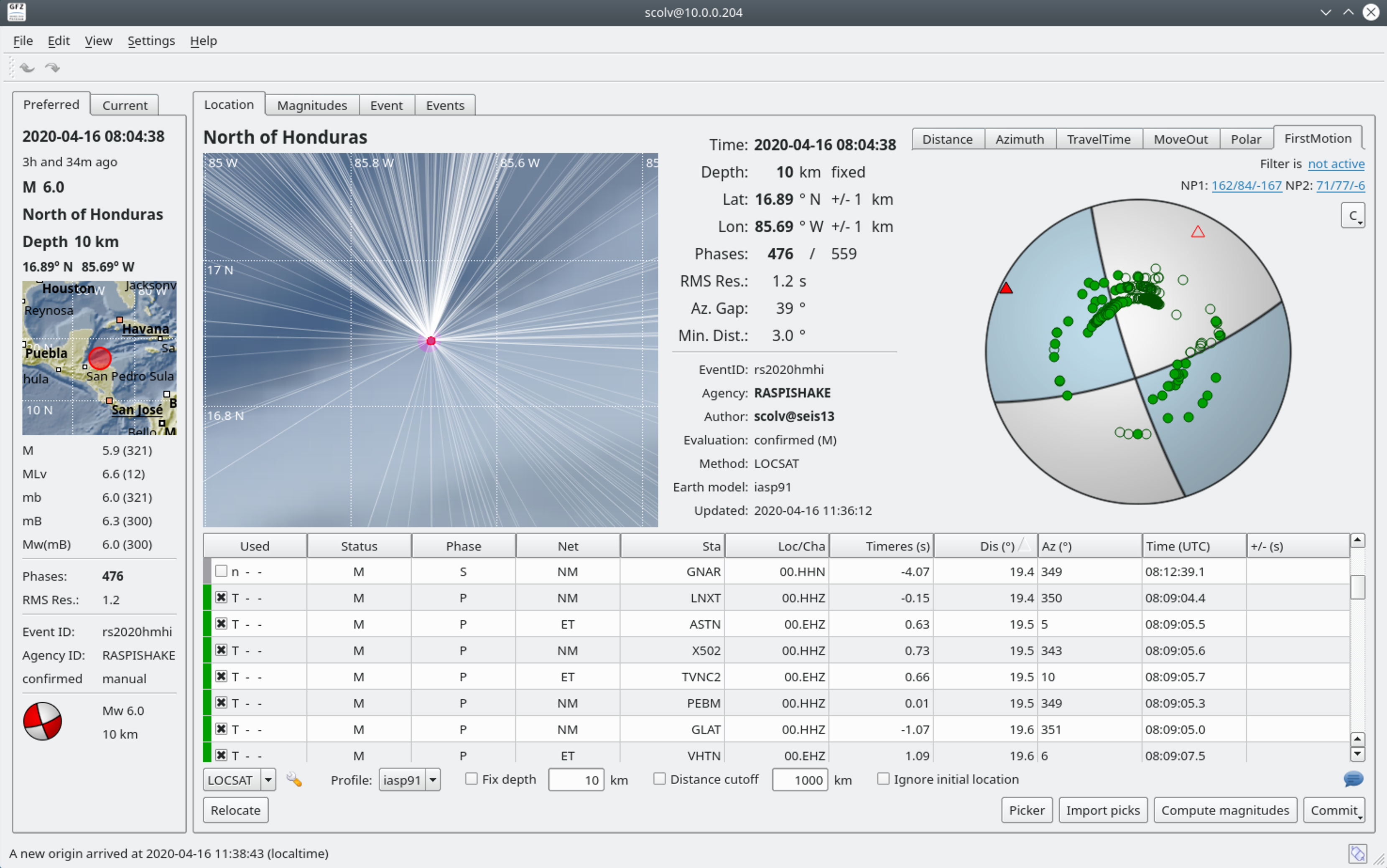
Mexico – M6.1 – May 22, 2020 at 08:46:06 UTC
173km ESE of San Jose del Cabo, Mexico
| Latitude | Longitude | Depth (km) | Dist (Deg) | Dist (Km) | Azimuth | |
|---|---|---|---|---|---|---|
| 22.403 | -108.164 | 10.0 | 32.7 | 3,634 | 49.9 |


Local SeisComP3 P-wave Arrivals


| Latitude | Longitude | Depth (km) | Dist (Deg) | Dist (Km) | Azimuth | |
|---|---|---|---|---|---|---|
| 22.403 | -108.164 | 10.0 | 32.7 | 3,634 | 49.9 |
Local SeisComP3 P-wave Arrivals
| Latitude | Longitude | Depth (km) | Dist (Deg) | Dist (Km) | Azimuth | |
|---|---|---|---|---|---|---|
| 38.159 | -117.875 | 2.8 | 32.7 | 3,628 | 73.2 |
The May 15, 2020 M 6.5 earthquake 56 km west f Tonopah, Nevada, occurred as the result of strike slip faulting in the shallow crust of the North America plate. Preliminary focal mechanism solutions for the event, which describe the style of faulting in an earthquake, indicate slip likely occurred on a steeply dipping fault striking either east-west (left-lateral) or north-south (right-lateral). This earthquake occurred within the Walker Lane, an active zone of seismicity roughly aligned with the California-Nevada border. Tectonically, the Walker Lane accommodates up to 25% of the North America:Pacific Plate motion, with the remainder mostly accommodated on the San Andreas fault system.
About two dozen M5+ earthquakes have occurred within 100 km of this event over the past 50 years, mostly to the west and south. Two M6+ events have occurred over the same region in the past century – a M 6.5 earthquake 40 km to the northwest in January 1934, and a M 6.8 event 50 km to the north in December 1932. Both of these earthquakes caused severe local shaking (MMI VIII); the 1932 earthquake is documented to have caused damage in the sparsely populated surrounding region. As of 12:00 UTC, 6 M4+ aftershocks have occurred since the M 6.5 earthquake, extending over a region about 30 km to the west of the mainshock.

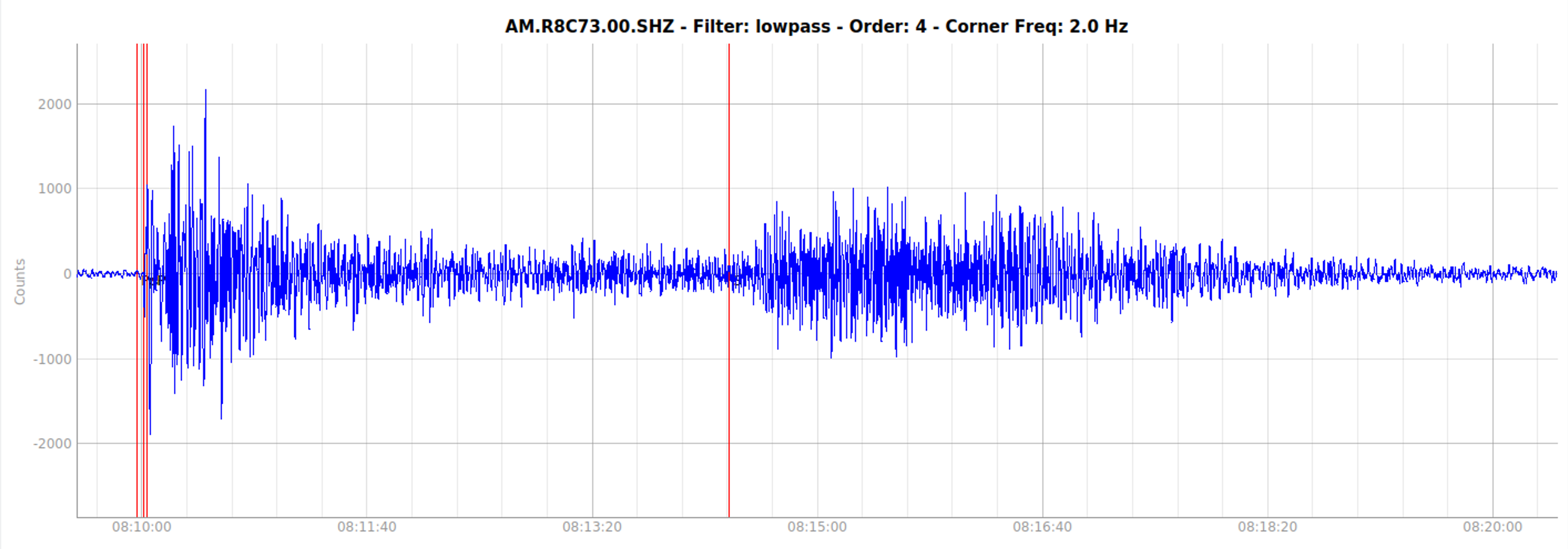
Spikes in image due to RF interference
Local SeisComP3 P-wave Arrivals


| Latitude | Longitude | Depth (km) | Dist (Deg) | Dist (Km) | Azimuth | |
|---|---|---|---|---|---|---|
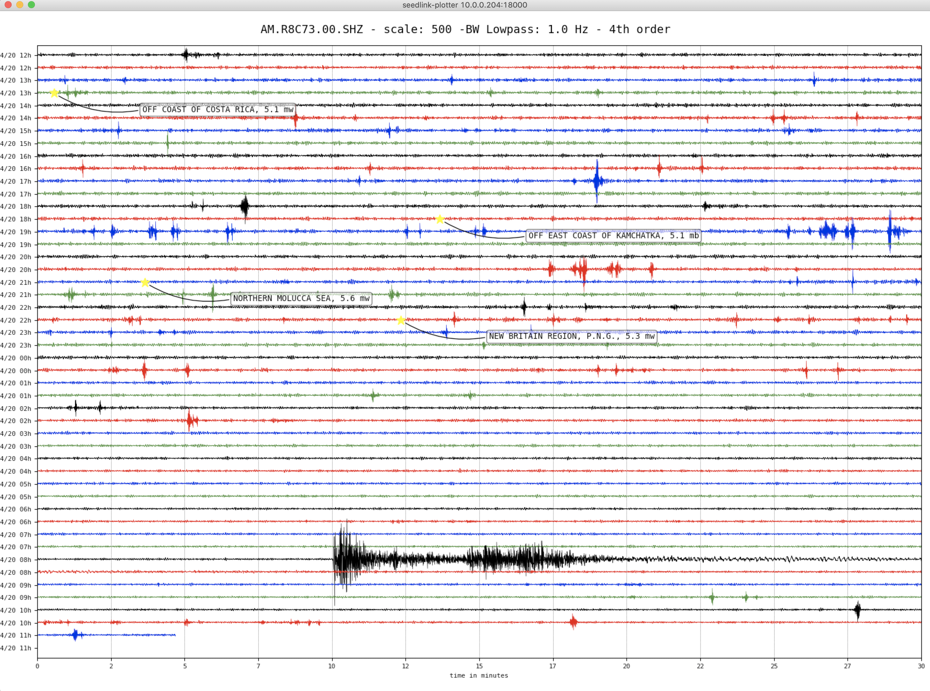
| -6.795 | 129.861 | 107.0 | 139.9 | 15,540 | 30.5 |


Local SeisComP3 P-wave Arrivals


| Latitude | Longitude | Depth (km) | Dist (Deg) | Dist (Km) | Azimuth | |
|---|---|---|---|---|---|---|
| 34.205 | 25.712 | 17.0 | 76.5 | 8,501 | 309.4 |


Local SeisComP3 P-wave Arrivals


| Latitude | Longitude | Depth (km) | Dist (Deg) | Dist (Km) | Azimuth | |
|---|---|---|---|---|---|---|
| 17.937 | -66.727 | 9.0 | 23.4 | 2,593 | 342.6 |
The May 2, 2020, M 5.5 earthquake offshore of southwest Puerto Rico occurred as the result of oblique normal faulting at shallow depth. Preliminary focal mechanism solutions for the earthquake indicate faulting occurred as the result of slip on either a steeply dipping plane striking to the northeast, or on a moderately dipping plane striking to the southwest. At the location of this event, the North America plate converges with the Caribbean plate at a rate of about 20 mm/yr to the west-southwest. The location, depth, and focal mechanism solution for the event are consistent with an intraplate tectonic setting, with slip occurring within the lithosphere of the Caribbean plate rather than on the plate boundary interface.
This earthquake occurred near the damaging January 6, 2020 magnitude 6.4 earthquake and is an aftershock of that earthquake. The earthquake is part of a vigorous sequence in the same region that has included hundreds of small earthquakes, beginning in earnest with a M 4.7 earthquake late on December 28 and a M 5.0 event a few hours later. The sequence has included six events magnitude 5.5 and larger and over a thousand magnitude 3.0 and larger events.
Tectonics in Puerto Rico are dominated by the convergence between the North America and Caribbean plates, with the island being squeezed between the two. To the north of Puerto Rico, North America subducts beneath the Caribbean plate along the Puerto Rico trench. To the south of the island, and south of today’s earthquake, Caribbean plate lithosphere subducts beneath Puerto Rico at the Muertos Trough. This ongoing earthquake sequence is occurring in the offshore deformation zone bound by the Punta Montalva Fault on land and the Guayanilla Canyon offshore.


Local SeisComP3 P-wave Arrivals


| Latitude | Longitude | Depth (km) | Dist (Deg) | Dist (Km) | Azimuth | |
|---|---|---|---|---|---|---|
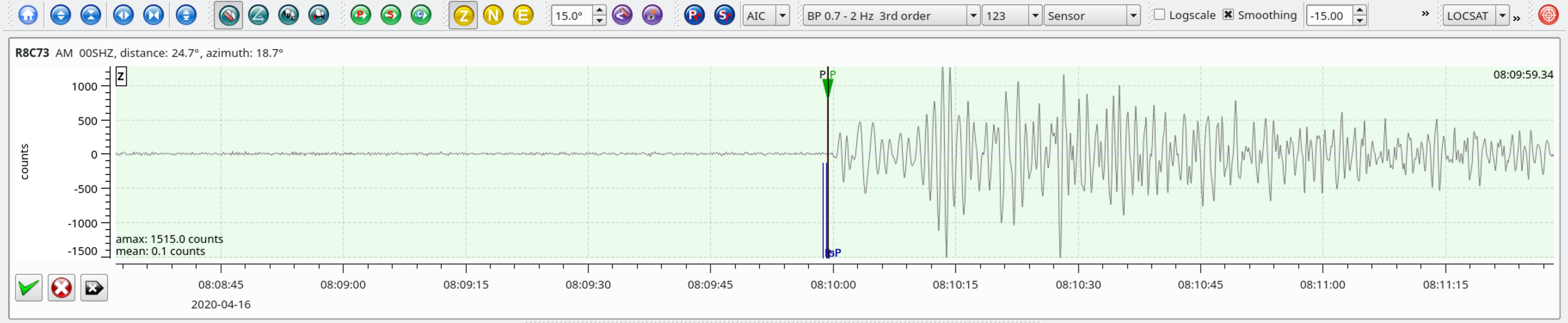
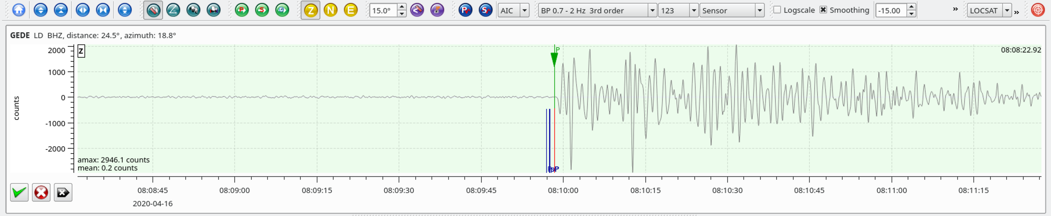
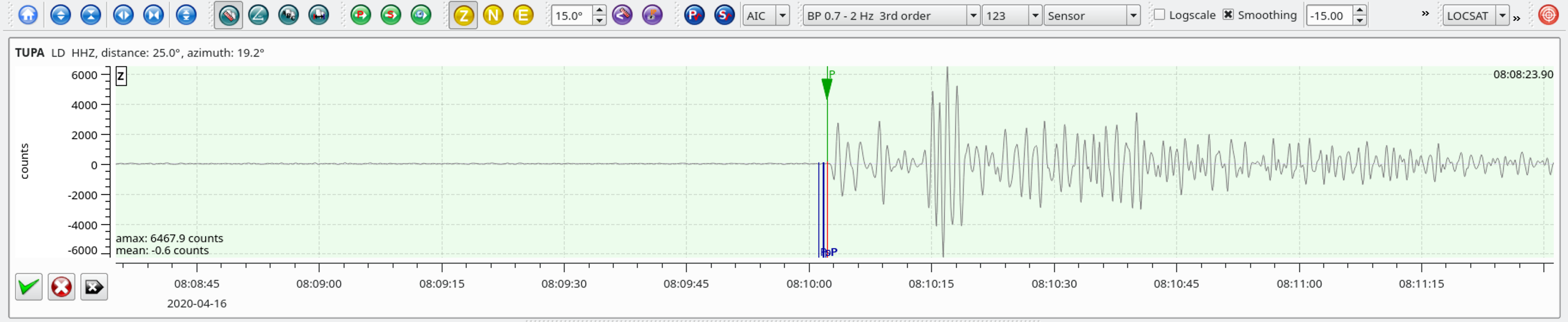
| 16.933 | -85.710 | 10.0 | 24.7 | 2,739 | 18.8 |
Local SeisComP3 P-wave Arrivals