On November 2, 2018 A strong squall line (QLCS) moved through southeastern Pennsylvania. Strong rotation at places along the leading edge of the line (not uncommon in these systems) resulted in the Mt. Holly NJ NWS Forecast Office to issue two tornado warnings. Although no tornadoes touched down, there was strong rotation as seen in the images below. Despite the tornado warnings, there was no lightning observed as the line move through the area.
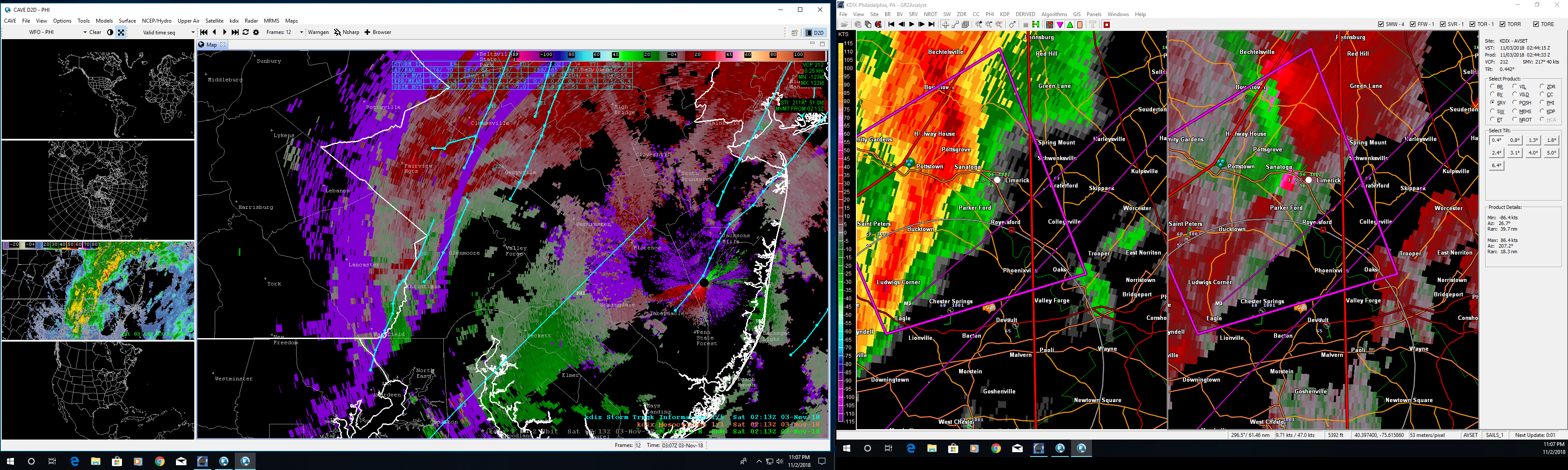
This image shows AWIPS II (left panel), and GR2 Analyst (right panel) Storm Relative Motion displays from the Fort Dix NJ Nexrad radar (KDIX). The right panel clearly shows rotation near Limerick PA (red and green next to each other).
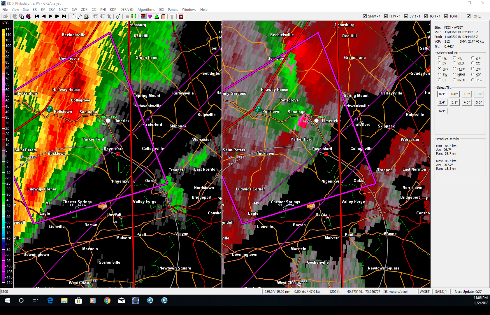
GR2 Analyst screenshot showing the strong couplet that generated the tornado warning.
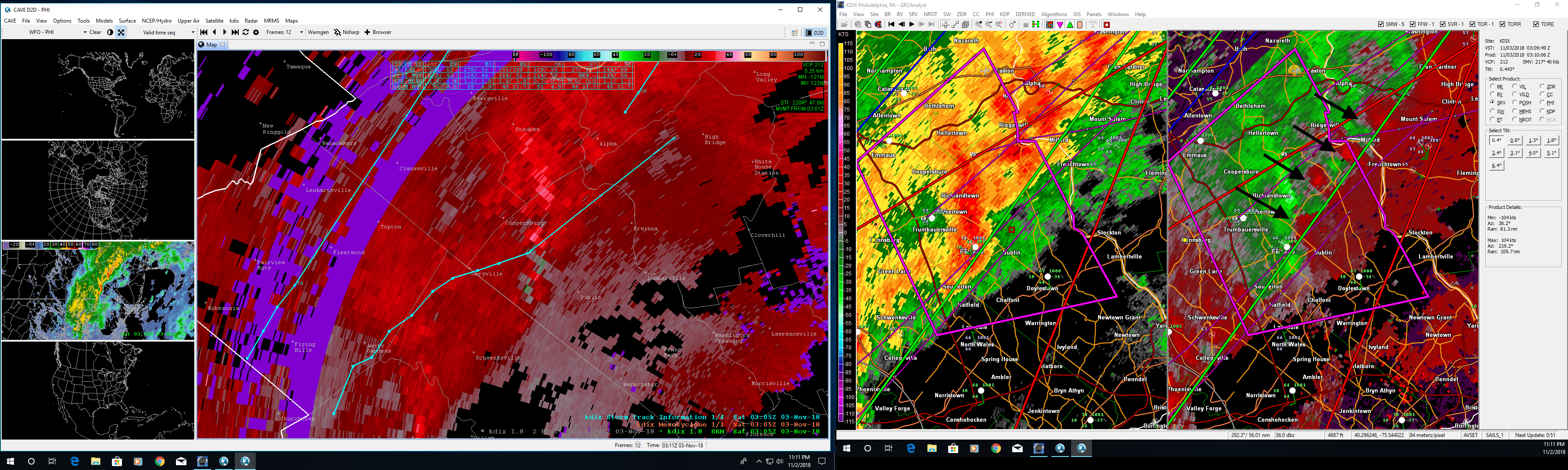
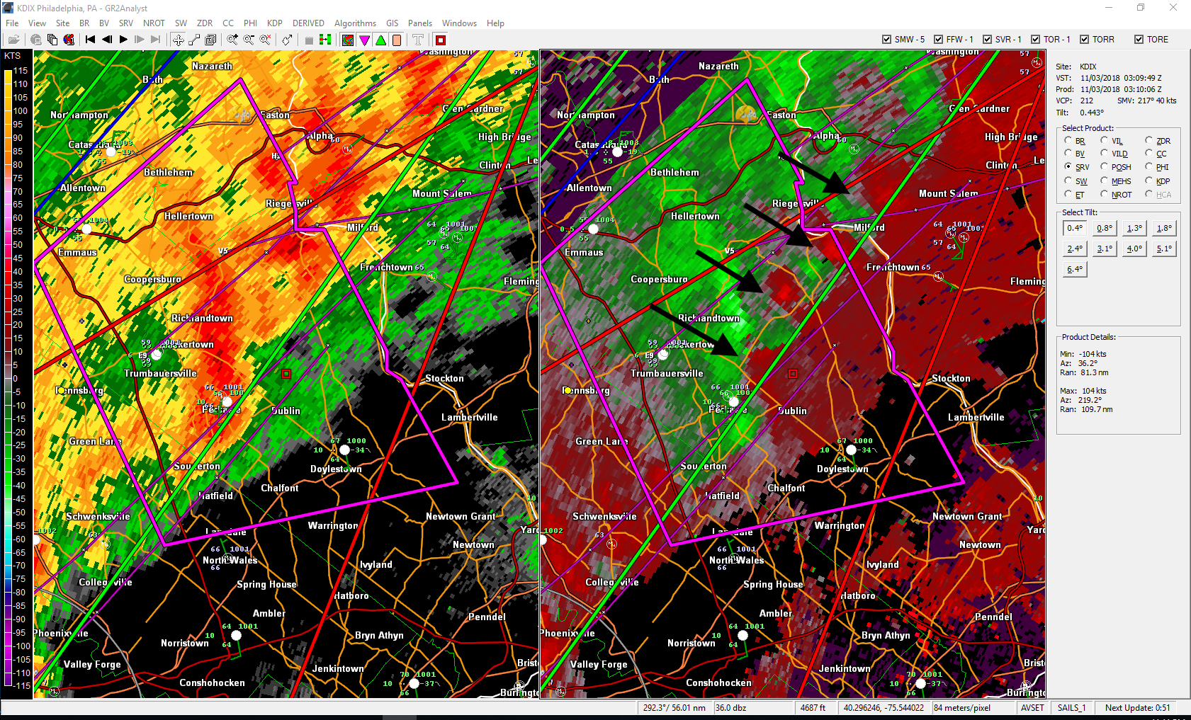
The arrows in the right panel of this image show areas of possible rotation along the leading edge of the squall line.
GR2 Analyst screenshot showing the multiple areas of rotation.
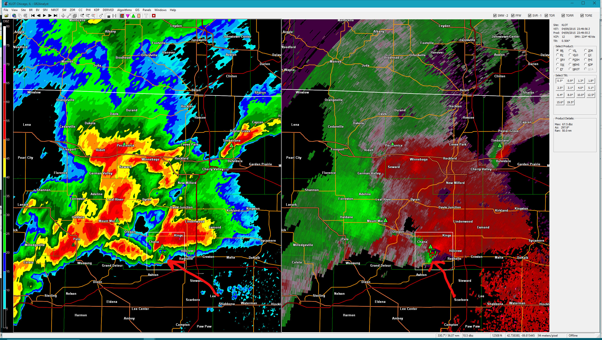
May 6th was the most active day so far in 2015. And it was only the beginning of several days of severe weather in the great plains.
While not a particularly notabable tornado (although it is a large code), this video very clearly shows the structure of a classic supercell. On the right is the flanking line with the main updraft (mesocyclone) and tornado in the center. The left side of the storm shows the hail core and forward flank downdraft (FFD).
Here is the 0.5 deg reflectivity and storm-relative velocity images in GRLevel2:
This GRLevel2 volumetric image (reflectivity at 40db) clearly shows the tornado:
PROGRESSIVE...MULTI-STREAM FLOW WILL PREVAIL OVER THE CNTRL AND ERN
 U.S. THIS PERIOD...DOWNSTREAM FROM WRN STATES SPLIT. STRONG
 SHORTWAVE TROUGH NOW EXITING THE CNTRL HIGH PLNS SHOULD ACCELERATE
 ENE INTO ERN IA THIS EVE...BEFORE FURTHER ACCELERATING AND TURNING
 NE TO NEAR SSM EARLY FRI AS NRN BRANCH IMPULSE AMPLIFIES SE INTO MN.
 AT THE SAME TIME...WEAKER LEAD DISTURBANCE NOW CROSSING THE OZARKS
 SHOULD MOVE NE INTO THE MID-OH VLY BY THIS EVE...AND INTO NY/PA
 EARLY FRI...AS DEEP SWLY FLOW STRENGTHENS ACROSS THE E-CNTRL AND ERN
 U.S.
AT THE SFC...NW MO LOW EXPECTED TO DEEPEN NEWD INTO SRN WI BY THIS
 EVE...AND UNDERGO FURTHER DEEPENING AS IT REACHES THE SSM AREA EARLY
 FRI. COLD FRONT TRAILING SSW FROM THE LOW SHOULD STRENGTHEN AND
 ACCELERATE E ACROSS THE MID-MISSISSIPPI VALLEY AND OZARKS BY LATE
 TODAY...AND INTO THE UPR OH...TN...AND LWR MS VLYS EARLY FRI...WHILE
 MORE DIFFUSE WARM FRONT ADVANCES N INTO LWR MI.
IN SUMMARY...THE OVERALL SET-UP SUPPORTS A BROAD AREA WITH AN
 APPRECIABLE RISK FOR SVR WEATHER LATER TODAY THROUGH EARLY FRI...BUT
 WITH MITIGATING FACTORS THAT LIKELY WILL KEEP THE CORRIDORS OF
 GREATEST RISK SOMEWHAT FRAGMENTED AND MULTI-MODAL.
...MID-MS VLY TO SRN GRT LKS THIS AFTN THROUGH EARLY TNGT...
 SEVERAL FACTORS MAY COMBINE TO YIELD A MESOSCALE CORRIDOR OF
 SOMEWHAT ENHANCED SVR THREAT...INCLUDING THE POTENTIAL FOR A COUPLE
 STRONG TORNADOES...OVER THE ERN IA/NE MO/NRN IL/SRN WI AREA LATER
 TODAY INTO EARLY TNGT. PERSISTENT HEIGHT FALLS ACROSS
 REGION...LARGELY DUE TO AMPLIFICATION OF UPSTREAM...LARGER-SCALE
 TROUGH...WILL OFFSET SINKING/DESCENT OCCURRING IN WAKE OF LEAD UPR
 IMPULSE AND EMBEDDED MCV NOW CROSSING THE OZARKS. AT THE SAME
 TIME...SATELLITE SUGGESTS LIKELIHOOD FOR AT LEAST MODEST SFC HEATING
 AHEAD OF COLD FRONT AND DEEPENING SFC LOW APPROACHING FROM NW MO.
WITH 700 MB SWLY WINDS INCREASING TO AOA 60 KTS ATOP 40+ KT SSW FLOW
 AT 850 MB...HODOGRAPHS WILL BE FAVORABLE FOR SUSTAINED SUPERCELLS
 WITH LARGE HAIL. THE DIRECTIONAL COMPONENT TO LOW-LVL SHEAR LIKELY
 WILL NOT BE GREAT. BUT COMBINATION OF STRENGTHENING FLOW AND
 EXPECTED BACKING OF NEAR-SFC WINDS/ENHANCED SRH IMMEDIATELY AHEAD OF
 SFC LOW SUGGEST THAT A CORRIDOR OF HEIGHTENED TORNADO POTENTIAL
 COULD EVOLVE LATER THIS AFTN...BEFORE THE STORMS MERGE INTO BROKEN
 LINES/SMALL CLUSTERS EARLY TNGT. ALTHOUGH CLOUDS AND SHOWERS MAY
 DELAY NWD ADVANCE OF WARM FRONT ACROSS IL/IND...STRENGTHENING SFC
 PRESSURE FALLS/TRACK OF SFC LOW FURTHER INDICATE THAT THE SVR THREAT
 COULD EXTEND NWD INTO SRN WI AND SW LWR MI...WITH DMGG WINDS
 BECOMING THE DOMINANT THREAT OVER TIME.
SPC Mesoscale Discussions relevant to the Illinois tornadoes: